Perpetual Motion Machines

Team Rants ventured out into the Whites again for more peakbagging adventure. Of the officially listed 48 peaks in the White Mountains that top out over 4000' we've scaled about 3/4 of them. Of the peaks yet to be hiked, several of them are clustered in the remote Pemigewasset Wilderness. After careful review of the map, a circuit over several of these peaks (Hale, Zealand, West Bond, South Twin, and North Twin) was a possibility. The option was intriguing.
My strong interest in hiking over the years has resulted in a large accumulation of knowledge about the White Mountains; its trails, terrain, and history. An interesting thing about the Whites is that some trails that lead to various peaks and points of interest have fallen into disuse and are no longer officially maintained by the AMC (Appalachian Mountain Club). Some of these trails are no longer marked on topographic or trail maps. While the marked trails are the most used, some folks in the know continue to hike the unmarked "lost trails". Several years back, I had read somewhere about a trail that at the time was used by a local firewarden to reach a firetower located on the summit of Mt. Hale. Today, the firetower is no longer there and the firearden's trail is no longer marked on trail maps. However, even though the trail is no longer marked, it still exists - providing an alternative route to the summit. I knew that this knowledge was useful because the starting location of the lost firewardens trail branched off of an existing marked trail that led into a different section of the Pemi Wilderness. What this meant was that a long loop hike over many peaks - beginning and ending at the same parking lot - could be possible. The only thing that was required to successfully do this was find the unmarked Firewarden's Trail leading up to the summit of Mt. Hale. From there, the rest of the loop would be easy to follow because it would be all on marked and maintained trails.
The loop option was too attractive to ignore. One thing about reaching any of the peaks in the Pemi - it takes a lot of walking to reach them. The loop option gave us the chance to bag a lot of the peaks all in one circuit. But how do you find the lost Firewarden's Trail? I had no idea what the state of the trail was in. Was it clearly visible? Was it overgrown like hell? Would following the trail be a rough bushwhack into unknown territory? We have not bushwhacked in the Whites before and have no interest to do so. However, it seemed that from the limited descriptions I was able to find, of people who have hiked the Firewarden's Trail in the past few years, have remarked on the ease by which one can follow the trail - all it takes is some patience in locating its beginning point.
So we took a chance with this plan. We'd attempt the loop option and hope we'd be able to find the Firewarden's Trail. If we hit that, then the rest of the pieces would fall into place. We'd plan to do this as a 2-day hike and camp out deep in the Pemi at a wilderness tentsite maintained by the AMC. We've done a few overnights before. I packed my backcountry stove, a lightweight cooking pot, some fuel, a tent, bag, and sleeping pad, as well clothes, camera, and water purifier. For food we packed energy bars as well as the makings for a backcountry dinner - a sealed pouch of tunafish and some rice to cook. We'd season the rice with some dehydrated soup veggie soup mix and add the tuna in for a one-pot dish. It's haute cuisine for sure, but only because of the elevation at which we'd be eating - not because of the meal's sophistication.
So we packed up what we needed to and headed to the hills. One precaution we took was to borrow a GPS unit from my wife's work. Her company produces mapping software and we figured we'd increase our chances of success (as well as safety) by bringing along a unit with a touchpad color screen. We parked the car, locked the doors, and hit the trail with fully loaded packs. The weather forecast promised dry air and clear skies. However, clouds covered the peaks and blustery winds shook the trees. It was not what we had expected, but we saw from weather maps that high pressure was building in, so we trusted that conditions would improve along the way into the hike.
The instructions I had were not very well written. We hiked for a mile on official path and came to a river crossing. This was to be the point where we'd go off-trail and seek out the start of the Firewarden's trail. We followed a "herd path" that ran parallel to the river. The instructions were obscure and clearly warned that following this herd path would not lead you to where you wanted to go. I scrambled up an embankment to get my bearings and see if I could match landforms to the paper description that I had. I backtracked a bit, and then returned. We moved further along the herd path and then I saw it - a sloping trail that came at us from a direction behind us. The instructions described the path as following the remnants of an old jeep trail, and here looking at this fern covered flat you could clearly tell that this was man-made. We looked up the slope and positively identified a beaten path leading forward - we had found it.
So on we hiked. The GPS was helpful as it gave us peace of mind that we could see our progress in relation to where we started and where we were heading - the summit of Mt. Hale. As for being a "lost trail" the Firewarden's path was easily identifiable. It ascended at an easy grade with long switchbacks through a beautiful open forest of ferns and birches. At no time did we think we were lost. In fact, at some points further up closer to the summit the footway was more visible than even some official maintained trails that we have hiked. I was really psyched that this had worked out. Reaching the 3 miles hiked mark, we leveled out through the stunted spruce out onto Hale. The summit barely tops out over 4000' and clouds obscured all views. Not a big deal though as I have heard that Hale offers little in the way of views anyways. We didn't stay for long, and pushed forward onto official trail. Our experience hiking a lost trail was now in the past.
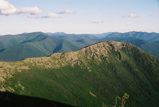
We lost some elevation and reached Zealand Hut. The view from the hut's steps towards Zealand Notch is fantastic. It was also at this point in our hike that cloud cover began to melt away; with sun and blue sky making an appearance. We sampled some of the hut's lunchtime offerings: veggie chili and ginger pumpkin soup, as well as fresh bread and carrot cake. With fuel in our bodies we pushed on forward, regaining the elevation that we had lost in order to attain the Zeacliff outlook and Zealand ridge - our pathway into the Pemi. The views from Zeacliff are some of the best in the Whites. You get a closeup view of slide-scarred Whitewall Mtn as well as expansive views south towards Carrigain and Carrigain Notch. We lingered here for a bit, and then moved on forward to continue to cover ground. Due to the remoteness, this area of the Whites is a favorite destination for backcountry campers, and in order to get a tentsite at the Guyout shelter you have to arrive early (first come first serve). The ridge from Zealand was bright and open and traveled along relatively flat granite slabs and high alpine plateau for several miles. Along the way you pass interesting features, including the remote Zealand Pond. Our venture along this ridge brought us to our next peak to bag - Zealand. As a point of interest, it is practically worthless - no views at all. However, with Zeacliff and Zealand Pond as attractions along the way hiking to Zealand is not without purpose. All we thought was, "Hey, another peak down. Time to keep moving." So we did.
The trail meanders along the ridge and deeper into the Pemi. Treeline begins to lower as you gain the crest of Mt. Guyout. I was nearing familiar territory and yet much of this was unfamiliar. Two times before I had been to Mt. Guyout - both times clouds and rainstorms moved in and obscured all views. So with great anticipation I looked foreward to seeing the views I had missed before. And beyond words they views did not disappoint. Ridgelines and mountainscapes all around as far as you could see. We stopped briefly to take a breather, but it was understood that to linger here meant the possibility that we would lose out on securing a tent platform to camp out at. So we pushed on. With one eye on the rocky footpath, I managed to take this picture of us moving along through the alpine glory surrounding us. It's hiking moments like these where the endorphines are up that you regain all your strength and energy back and muscle pains seem to melt away.
We arrived at the campsite and had just missed securing a tent platform by about 15 minutes. The site caretaker, an employee of the AMC, offered up available remaining space in the campsite shelter - an open sided hut with two bunk levels that could sleep 12 (cramped) if necessary. He had overflow tent sites available back up on the ridge, but he had to book up the shelter first before he could allow people to camp at the overflow spots. Needless to say, after looking in the shelter to investigate - and interrupting some gruff hiker cooking his dinner - the prospect of being cooped up in this cell was not exactly enticing. This particular area of the Whites where we were located is right on the border between designated National Forest land and land under Wilderness designation. Wilderness land is under additional restrictions regarding usage and backcountry camping is one of them. It is possible to backcountry camp legally in Wilderness, but you have to take special efforts to minimize your presence and you must not camp within a certain range of a number of features: streams, rivers, lakes, treeline, trails, and designated campsites. However, go outside of Wilderness and the restrictions relax somewhat. A large reason for this has to do with the effects that old-style camping had on the woods. It used to be that people went into the woods with frying pans, hatchets, big canvas tents and large gear and camped in a manner that involved felling a lot of trees and building big bonfires. Eventually, this style of camping began to take it's toll - especially in the 70's when people really went out into the woods in force and added to the standard practices by creating a lot of garbage - often in the form of pull-tab beer cans. People began to take notice that hikers and campers were trashing the woods and in response the land governing agencies and hiking/environmental communities developed and instituted a policy of "Leave No Trace".
Leave No Trace in itself is a noble practice - you carry in what you carry out and when in the woods you try to minimize your impact on the environment as much as possible. For camping, it means that campers should disperse into the woods and not reuse older campsites - unless those campsites are officially authorized for continuous use (and often times these sites are actually tent platforms that can be removed later with limited impact on the ground below). This background explains a bit of the dilemma we found ourselves in - we didn't want to camp in the shelter with others, and the caretaker was warning us that unauthorized camping up on the ridge was liable to get us a $250 fine from the Forest Ranger. This is certainly true, but what I realized is that the area he was pointing me towards, the area that was restricted, was into the Wilderness and I realized that if we backtracked the direct we came from we'd move away from the restricted zone and into general National Forest and therefore be able to camp anywhere we chose. (The area we were in is surrounded by Wilderness designation on three sides - but not in the direction we came from).
So we moved back up the ridge and after a brief bit of investigation, found an area offtrail that provided enough flat open space on which we could pitch our tent. Indeed, at this elevation finding a suitable ground for placing a tent is not simple. Stunted spruce trees are often space about 2 feet from each other. The forest is incredibly dense in this environment and to find an area that has broadly spaced trees and flat open ground free of rocks, stumps and roots is not an easy task. However, we did find an area that was not perfect, but would suit us and allow us to set up the tent - then we could cook dinner and eat! I brought with us a backcountry stove and firing it up was easy. Dinner wasn't haute but it was hot and that's what mattered. Also, my wife was a sweetheart and packed in a special treat for me - M&M brownies with a candle on top (it was my birthday). It was truly a fantastic moment and she made it better.
The sun was setting and we were very close to one of the best vantage points in all the Whites - the airy perch known as West Bond. The food in us gave us energy, and the thought of sublime sunset views inspired us to hike again. It was not terribly exertive - just about a half mile away, and we walked the sidtance in no time (it was so much easier to hike without our heavy laden packs on). We climbed up the last steep section and cresting the top instantly rendered speechless but what sights greeted us.
The scarred face of the Bondcliff glowed in the evening sun. The fresh air from the north provided a sharply focused view of surrounding ridges free from the obscuring effects of haze and humidity. In time, shadows crept up the slopes of our neighbor. It was a glorious setting and the perfect punctuation to a perfect day. It was difficult to pull ourselves away from that perch, yet we did. Our tired bodies and feet demanded rest so we returned to our camp.
Exhausted, we went to bed and tried to to fall asleep. I could feel my body trying to will it so, but the mind would not let it happen. Every single noise out there in the woods was picked up by the ears and the imagination. We heard voices one time, and another time the revving engines of motorcycles (very strange indeed - we were perhaps 15 miles from the nearest roads and surrounded by high mountains all around). Then later, the deep booms of a premature 4th of July celebration rumbled from a far off town. It was a strange thought knowing that out there was a lot of revelry and action - yet here was nothing but a natural blanket of trees and mountains sparse with civilization; a silence momentarily interrupted by the world out there. Indeed, it took a while - it took perhaps 3-4 hours - but eventually we slept.
The next morning was uneventful. We packed up our camp, powered down some Powerbars, and headed on out. Our journey would take us over the Twins - North and South. Views from South Twin were far reaching. From North Twin they were exceptional. We looked back over at South Twin and the land we had visited in the course of our adventure. The hike out was several more miles and would take several more hours and by the end our feet would be smoking. Regardless of the exertion it was all worth it. There's a great land out there.


6 Comments:
I hope you used your GPS to mark the trail for the next guy :)
Thank you for that amazing account and the pictures. What a great way to spend a birthday!
http://birthday-ideas.blogspot.com/
Rants - I will admit to mostly skimming your post because who actually reads anything anymore, but I did want to comment on your beautiful photographs. I don't know if you noticed, but almost every picture was in three parts: 1) the less colored foreground showing the close up of the generally scrubby looking trees or rocks, 2) the more distant peaks and valleys which are more uniformly green and dark and 3) the beautifully blue skies with puffy clouds for accent. The three layered look draws the eye.
Thanks Carpoolguy. Indeed, I use the Rule of Thirds quite a lot when I shoot photos
http://en.wikipedia.org/wiki/Rule_of_thirds
Interesting...I know I've read that you should have either the sky or the earth fill 1/3 of the frame (instead of 1/2), but I hand't heard of it as the rule of thirds. And I never really considered the vertical thirds, either. Not too late to teach an old dog.
PYTHAGORAS!!!
Post a Comment
<< Home