Saturday, July 16, 2005

Stranger in a Strange Land
For work this week I went down to the Hynes Convention Center in Boston to check out MacWorld. Yeah, go send the guy who has few gadgets to go check out a show based around them. I walked into the showroom and sensed that I was perhaps the least enthusiastic of all the attendees in the room. It was as though I was a Southern chef shopping at a farmer's market made up strictly of avocado farmers. A lot of the stuff on display at the show was built around the iPod. Portable desktop speakers, designer skins for the iPod; there was even someone selling stylish handbags that had a iPod friendly compartment built in. I did my duty there as required but frankly I really just didn't care about the stuff that was there.

Brevity
After several longer posts, here is a shorter one.

Sunday, July 10, 2005

Perpetual Motion Machines


Team Rants ventured out into the Whites again for more peakbagging adventure. Of the officially listed 48 peaks in the White Mountains that top out over 4000' we've scaled about 3/4 of them. Of the peaks yet to be hiked, several of them are clustered in the remote Pemigewasset Wilderness. After careful review of the map, a circuit over several of these peaks (Hale, Zealand, West Bond, South Twin, and North Twin) was a possibility. The option was intriguing.

My strong interest in hiking over the years has resulted in a large accumulation of knowledge about the White Mountains; its trails, terrain, and history. An interesting thing about the Whites is that some trails that lead to various peaks and points of interest have fallen into disuse and are no longer officially maintained by the AMC (Appalachian Mountain Club). Some of these trails are no longer marked on topographic or trail maps. While the marked trails are the most used, some folks in the know continue to hike the unmarked "lost trails". Several years back, I had read somewhere about a trail that at the time was used by a local firewarden to reach a firetower located on the summit of Mt. Hale. Today, the firetower is no longer there and the firearden's trail is no longer marked on trail maps. However, even though the trail is no longer marked, it still exists - providing an alternative route to the summit. I knew that this knowledge was useful because the starting location of the lost firewardens trail branched off of an existing marked trail that led into a different section of the Pemi Wilderness. What this meant was that a long loop hike over many peaks - beginning and ending at the same parking lot - could be possible. The only thing that was required to successfully do this was find the unmarked Firewarden's Trail leading up to the summit of Mt. Hale. From there, the rest of the loop would be easy to follow because it would be all on marked and maintained trails.

The loop option was too attractive to ignore. One thing about reaching any of the peaks in the Pemi - it takes a lot of walking to reach them. The loop option gave us the chance to bag a lot of the peaks all in one circuit. But how do you find the lost Firewarden's Trail? I had no idea what the state of the trail was in. Was it clearly visible? Was it overgrown like hell? Would following the trail be a rough bushwhack into unknown territory? We have not bushwhacked in the Whites before and have no interest to do so. However, it seemed that from the limited descriptions I was able to find, of people who have hiked the Firewarden's Trail in the past few years, have remarked on the ease by which one can follow the trail - all it takes is some patience in locating its beginning point.

So we took a chance with this plan. We'd attempt the loop option and hope we'd be able to find the Firewarden's Trail. If we hit that, then the rest of the pieces would fall into place. We'd plan to do this as a 2-day hike and camp out deep in the Pemi at a wilderness tentsite maintained by the AMC. We've done a few overnights before. I packed my backcountry stove, a lightweight cooking pot, some fuel, a tent, bag, and sleeping pad, as well clothes, camera, and water purifier. For food we packed energy bars as well as the makings for a backcountry dinner - a sealed pouch of tunafish and some rice to cook. We'd season the rice with some dehydrated soup veggie soup mix and add the tuna in for a one-pot dish. It's haute cuisine for sure, but only because of the elevation at which we'd be eating - not because of the meal's sophistication.

So we packed up what we needed to and headed to the hills. One precaution we took was to borrow a GPS unit from my wife's work. Her company produces mapping software and we figured we'd increase our chances of success (as well as safety) by bringing along a unit with a touchpad color screen. We parked the car, locked the doors, and hit the trail with fully loaded packs. The weather forecast promised dry air and clear skies. However, clouds covered the peaks and blustery winds shook the trees. It was not what we had expected, but we saw from weather maps that high pressure was building in, so we trusted that conditions would improve along the way into the hike.

The instructions I had were not very well written. We hiked for a mile on official path and came to a river crossing. This was to be the point where we'd go off-trail and seek out the start of the Firewarden's trail. We followed a "herd path" that ran parallel to the river. The instructions were obscure and clearly warned that following this herd path would not lead you to where you wanted to go. I scrambled up an embankment to get my bearings and see if I could match landforms to the paper description that I had. I backtracked a bit, and then returned. We moved further along the herd path and then I saw it - a sloping trail that came at us from a direction behind us. The instructions described the path as following the remnants of an old jeep trail, and here looking at this fern covered flat you could clearly tell that this was man-made. We looked up the slope and positively identified a beaten path leading forward - we had found it.

So on we hiked. The GPS was helpful as it gave us peace of mind that we could see our progress in relation to where we started and where we were heading - the summit of Mt. Hale. As for being a "lost trail" the Firewarden's path was easily identifiable. It ascended at an easy grade with long switchbacks through a beautiful open forest of ferns and birches. At no time did we think we were lost. In fact, at some points further up closer to the summit the footway was more visible than even some official maintained trails that we have hiked. I was really psyched that this had worked out. Reaching the 3 miles hiked mark, we leveled out through the stunted spruce out onto Hale. The summit barely tops out over 4000' and clouds obscured all views. Not a big deal though as I have heard that Hale offers little in the way of views anyways. We didn't stay for long, and pushed forward onto official trail. Our experience hiking a lost trail was now in the past.

We lost some elevation and reached Zealand Hut. The view from the hut's steps towards Zealand Notch is fantastic. It was also at this point in our hike that cloud cover began to melt away; with sun and blue sky making an appearance. We sampled some of the hut's lunchtime offerings: veggie chili and ginger pumpkin soup, as well as fresh bread and carrot cake. With fuel in our bodies we pushed on forward, regaining the elevation that we had lost in order to attain the Zeacliff outlook and Zealand ridge - our pathway into the Pemi. The views from Zeacliff are some of the best in the Whites. You get a closeup view of slide-scarred Whitewall Mtn as well as expansive views south towards Carrigain and Carrigain Notch. We lingered here for a bit, and then moved on forward to continue to cover ground. Due to the remoteness, this area of the Whites is a favorite destination for backcountry campers, and in order to get a tentsite at the Guyout shelter you have to arrive early (first come first serve). The ridge from Zealand was bright and open and traveled along relatively flat granite slabs and high alpine plateau for several miles. Along the way you pass interesting features, including the remote Zealand Pond. Our venture along this ridge brought us to our next peak to bag - Zealand. As a point of interest, it is practically worthless - no views at all. However, with Zeacliff and Zealand Pond as attractions along the way hiking to Zealand is not without purpose. All we thought was, "Hey, another peak down. Time to keep moving." So we did.

The trail meanders along the ridge and deeper into the Pemi. Treeline begins to lower as you gain the crest of Mt. Guyout. I was nearing familiar territory and yet much of this was unfamiliar. Two times before I had been to Mt. Guyout - both times clouds and rainstorms moved in and obscured all views. So with great anticipation I looked foreward to seeing the views I had missed before. And beyond words they views did not disappoint. Ridgelines and mountainscapes all around as far as you could see. We stopped briefly to take a breather, but it was understood that to linger here meant the possibility that we would lose out on securing a tent platform to camp out at. So we pushed on. With one eye on the rocky footpath, I managed to take this picture of us moving along through the alpine glory surrounding us. It's hiking moments like these where the endorphines are up that you regain all your strength and energy back and muscle pains seem to melt away.

We arrived at the campsite and had just missed securing a tent platform by about 15 minutes. The site caretaker, an employee of the AMC, offered up available remaining space in the campsite shelter - an open sided hut with two bunk levels that could sleep 12 (cramped) if necessary. He had overflow tent sites available back up on the ridge, but he had to book up the shelter first before he could allow people to camp at the overflow spots. Needless to say, after looking in the shelter to investigate - and interrupting some gruff hiker cooking his dinner - the prospect of being cooped up in this cell was not exactly enticing. This particular area of the Whites where we were located is right on the border between designated National Forest land and land under Wilderness designation. Wilderness land is under additional restrictions regarding usage and backcountry camping is one of them. It is possible to backcountry camp legally in Wilderness, but you have to take special efforts to minimize your presence and you must not camp within a certain range of a number of features: streams, rivers, lakes, treeline, trails, and designated campsites. However, go outside of Wilderness and the restrictions relax somewhat. A large reason for this has to do with the effects that old-style camping had on the woods. It used to be that people went into the woods with frying pans, hatchets, big canvas tents and large gear and camped in a manner that involved felling a lot of trees and building big bonfires. Eventually, this style of camping began to take it's toll - especially in the 70's when people really went out into the woods in force and added to the standard practices by creating a lot of garbage - often in the form of pull-tab beer cans. People began to take notice that hikers and campers were trashing the woods and in response the land governing agencies and hiking/environmental communities developed and instituted a policy of "Leave No Trace".

Leave No Trace in itself is a noble practice - you carry in what you carry out and when in the woods you try to minimize your impact on the environment as much as possible. For camping, it means that campers should disperse into the woods and not reuse older campsites - unless those campsites are officially authorized for continuous use (and often times these sites are actually tent platforms that can be removed later with limited impact on the ground below). This background explains a bit of the dilemma we found ourselves in - we didn't want to camp in the shelter with others, and the caretaker was warning us that unauthorized camping up on the ridge was liable to get us a $250 fine from the Forest Ranger. This is certainly true, but what I realized is that the area he was pointing me towards, the area that was restricted, was into the Wilderness and I realized that if we backtracked the direct we came from we'd move away from the restricted zone and into general National Forest and therefore be able to camp anywhere we chose. (The area we were in is surrounded by Wilderness designation on three sides - but not in the direction we came from).

So we moved back up the ridge and after a brief bit of investigation, found an area offtrail that provided enough flat open space on which we could pitch our tent. Indeed, at this elevation finding a suitable ground for placing a tent is not simple. Stunted spruce trees are often space about 2 feet from each other. The forest is incredibly dense in this environment and to find an area that has broadly spaced trees and flat open ground free of rocks, stumps and roots is not an easy task. However, we did find an area that was not perfect, but would suit us and allow us to set up the tent - then we could cook dinner and eat! I brought with us a backcountry stove and firing it up was easy. Dinner wasn't haute but it was hot and that's what mattered. Also, my wife was a sweetheart and packed in a special treat for me - M&M brownies with a candle on top (it was my birthday). It was truly a fantastic moment and she made it better.

The sun was setting and we were very close to one of the best vantage points in all the Whites - the airy perch known as West Bond. The food in us gave us energy, and the thought of sublime sunset views inspired us to hike again. It was not terribly exertive - just about a half mile away, and we walked the sidtance in no time (it was so much easier to hike without our heavy laden packs on). We climbed up the last steep section and cresting the top instantly rendered speechless but what sights greeted us.

The scarred face of the Bondcliff glowed in the evening sun. The fresh air from the north provided a sharply focused view of surrounding ridges free from the obscuring effects of haze and humidity. In time, shadows crept up the slopes of our neighbor. It was a glorious setting and the perfect punctuation to a perfect day. It was difficult to pull ourselves away from that perch, yet we did. Our tired bodies and feet demanded rest so we returned to our camp.

Exhausted, we went to bed and tried to to fall asleep. I could feel my body trying to will it so, but the mind would not let it happen. Every single noise out there in the woods was picked up by the ears and the imagination. We heard voices one time, and another time the revving engines of motorcycles (very strange indeed - we were perhaps 15 miles from the nearest roads and surrounded by high mountains all around). Then later, the deep booms of a premature 4th of July celebration rumbled from a far off town. It was a strange thought knowing that out there was a lot of revelry and action - yet here was nothing but a natural blanket of trees and mountains sparse with civilization; a silence momentarily interrupted by the world out there. Indeed, it took a while - it took perhaps 3-4 hours - but eventually we slept.

The next morning was uneventful. We packed up our camp, powered down some Powerbars, and headed on out. Our journey would take us over the Twins - North and South. Views from South Twin were far reaching. From North Twin they were exceptional. We looked back over at South Twin and the land we had visited in the course of our adventure. The hike out was several more miles and would take several more hours and by the end our feet would be smoking. Regardless of the exertion it was all worth it. There's a great land out there.

Tuesday, July 05, 2005

Old Dominion
Mrs. Rants and I recently returned from a week's vacation spent down in Virginia. The main reason we went was to attend a family reunion (on my side) taking place the first part of the week (in Virginia Beach) and the rest of the time we used to road trip around the state.

First off, if driving down there from NH, you're required to choose one of two miserable options to get to where you want to go. Either take I-95 through New Jersey, around Baltimore, around DC, and down through the bedroom town megalopolis that is Northern Virginia (with guaranteed delays, stop & go traffic, and slow-speed construction zones to contend with). Your other option is to drive through the Amish-like timewarp that marks the landscape of Delaware and the rest of the Delmarva peninsula (end result is to pay big $$$$ to drive over the cool Chesapeake Bay Bridge/Tunnel). Sure you'll see less traffic, but you'll also grow tired pretty quick of seeing Tyson chicken farms and fields of corn and soybeans. Nevertheless, we opted to marvel the Delmarva and so enamored were we by the sights that my wife slept through most of Maryland. Oh well, she didn't miss much...

In any case, we did reach Virginia Beach and by and large we liked the layout of the area. The beach had its share of honky-tonk but for the most part it retained some touch of class - the beachfront was not entirely infested with tattoo parlors. Indeed, entertainment for the beachgoing masses was provided by the US Military - thundering F/A-18 Super Hornets (based at nearby Oceana Naval Air Station) streaking overhead every 10 minutes or so. Interestingly enough, the arrival to the area of the Super Hornets (replacing the aged F-14 Tomcats of Top Gun fame) created a regional controversy - pitting supporters of the jets against neighbors who haven't taken as kindly to the new machinery. The issue has to do with the loudness of the jet engines - the Super Hornet is quite a lot louder than the older Tomcat. Encroaching development in recent years has also brought additional people into the area - with housing developments abutting the boundaries of the base. Supporters generally consider the increased loudness to be the sound of freedom and enthusiastically proclaim the bumper sticker I (heart) Jet Noise on their vehicles.

Coincidentally enough, my sister's husband is a navy pilot and he does rattle the neighborhood windows on occasion. We were graciously treated to a tour of the base and got to take a look at one of these F/A-18s up close. Simply awesome experience, sitting in the hangar looking out the open doors at plane after plane taking off in a fury of roar and jet flame. Early that evening, back at the family barbecue, we happened to meet another pilot who is stationed at the base. These guys are really unassuming and if seated next to them at a baseball game you would never guess what their occupation is. Interestingly enough, they tend not to embellish their exploits when asked by a civilian how it must be to fly one of these planes - they know that they have cool jobs and do extraordinary things. It goes without saying. However, needless to say, they also know that after meeting them, you'll be the one to gloss up the stories with colorful descriptions and boasting. They know you'll tell others that "Hey, I know a jet pilot". They know they'll be the talk at cocktail parties (when you need to use them as your conversational Ace in the Hole). They probably also know that they'll be blogged about - like now. I am sure the wow factor is their trump card and keeps people tolerating the jet noise.

Several days later, we left the area and moved on. Up to this point we had no concrete plan. We had a two night reservation at a campsite just outside of Richmond, but other than that the days were open. We knew on the way down that we'd drive around, and if we felt like it, tour some Civil War sites. I'm not, you might say, a Civil War junkie, but I do have interest and appreciation in the topic. I was clueless about the War up until several years ago when I devoted several months to reading historian Shelby Foote's three volume (and 3000 page) narrative on the conflict. Upon concluding that reading I was hooked. Mrs. Rants understood my interest in the topic and she herself was willing to tour the preserved locations of some of the most notable battlefields of the conflict - many of them of course located right in Virginia. She had her own reasons for going too: she loves the Virginia countryside, has an interest in history herself, and after reading Confederates in the Attic - a great narrative about hanging out with contemporary Confederate and Union re-enactors (many of them slightly bit nutty) hoped to see if some might be in costume there seeking to experience a "period rush".

Over the course of a warm and sunny southern afternoon, we followed the driving tour of four major battlefields - beginning at Fredericksburg (a Union loss), on to Chancellorsville (site of another Union loss), moving on to Wilderness Battlefield (billed as a stalemate though the Union suffered more casualties) and ending at the rural, peaceful setting of Spotsylvania (another stalemate and also the site of ferocious Union casualties). The sites themselves varied in terms of what state of preservation they were in: Fredericksburg was tiny (hemmed in by a downtown and major roads), Chancellorsville and Wilderness were essentially a few fields lined along a two-lane divided state highway. Spotsylvania was the most preserved with virtually no development or major roads slicing through. To best assist the understanding of what took place, National Park Service employees offered walking tours where they explained the bloody events that took place at these locations. These tour guides were superb, and their enthusiasm, storytelling abilities, and knowledge helped bring to life the history embedded at each of these sites. They helped immeasurably with the task of imagining what had taken place - pointing out treelines where thousands would have stood - lined up several rows deep firing a hailstorm of lead at their opponents. 
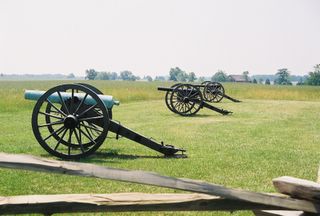
Cannons were placed at the locations they occupied during the conflicts - assisting the task of seeing gorgeous green Virginia countryside and transforming it into an imaginary scene of hell that at one time was not imaginary at all - but all too real.

Of all the day's sites, there is one experience I will never forget. Located within Wilderness Battlefield is a pulloff to a place called Ellwood. The present-day scene is stunning - rolling Virginia countryside, farms, trees & fields. A fine looking house surrounded by stately oak trees graces this area. A small path takes you no more than 100 yards out to the edge of a cornfield and near it a lone tree standing guard over a single gravestone. There is no person buried here - yet what remains lie here are singularly felt by Southerners past and present. The spot is both a remembrance of valor as well as a remembrance of defeat - that the remembered event marked the Confederacy's doom. What was here? Well, General Stonewall Jackson, a name of history, was perhaps the South's ablest and most daring warrior. During the battle of Chancellorsville, Gen. Jackson engaged a flanking attack against the Union foe that remains to this day one of the most daring feats in the entire history of warfare. In the very moment of highest victory, with nightfall descending and the confusion of fog and smoke swirling, Jackson was shot at by his own forces. His wounds were significant - requiring immediate attention. Doctors attended to Jackson and to stave off infection - amputated the General's arm. Jackson was moved further south towards Richmond - his arm remained behind and was taken into custody by a local family for proper handling. Jackson remained alive for several days, sometimes showing signs of improvement and recovery. However, it was not to last; a short while later he developed pneumonia and died. The news shocked all in the South - they knew he could not be replaced. Many felt that when he died, so did the fortunes of the South with him. Thinking back on this, I looked down at the gravestone and recognized the hallowed-ness of this ground. The grave is the resting spot of that severed arm; the arm that once commanded thousands into battle - the arm of a man forever known as Stonewall.


Changing speeds (several times over as you'll see), we touristed another attraction: Paramount's King's Dominion theme park. I should have begged off from going, not because I am afraid of roller coasters, but because I was a touch hung over (slung back Jack Daniels and cola sitting by the previous night's campfire). Man, I was getting the cold sweats. Ooof. Oddly enough, we showed up at the park at 9AM only to be greeted by locked gates and empty parking lots. Was this place shut down? We inquired at a Burger King across the street, What's the deal? We found out that the place doesn't open till 10AM! What kind of theme park opens so late in the morning? Is it because we're in the South and things are a bit slower? We sat in our car waiting for the front gate to open. This gave me some time to chug water and catch a needed nap. Finally the gates opened and we were allowed to proceed onward to the parking lot. Having arrived so early we were able to park in the closest lot to the walk-up entrance - only to be greeted by more locked gates! Its like being a salmon trying to get up a fish ladder - move forward into the next room and figure it all out before you can move up to the next waiting room. Finally they let us through that checkpoint and on we stepped through into the Main Street midway. We headed straight over to one of the heralded puke rides, only to be blocked by another gate and security guard. The big rides don't start until 10:30! What is the point of all this? Is this some maddening effort at crowd control? Had someone performed a flow analysis and determined that this was the best way to direct the paying customers efficiently? Man, it was ridiculous. Already we've spent an hour and a half at this place and I hadn't even got a chance to dine on a funnel cake. They were failing their mission to amuse!

10:30 hit and we were on our way. The first line we waited in was not that long, and the ride was one of those coasters that shoot you out at top speed straight up a vertical ramp. We strapped into the death car and coursed around the track to the launch area - one of those locations where they display some lights and purposefully delay you so as best to encourage your thinking (worrying) brain to jack up your pulse. BOOM! I swear to you, the ignition was beyond any roller coaster speed I've experienced. This was a whiplash ride and nothing more. In the first few milliseconds you've already whipsawed through several G's above and below the force of gravity. Hungover, I didn't think I was going to puke so much as have a heart attack - one of those victims you hear about on the news in the summertime about how they failed to heed the ride's warnings about "People with medical conditions, high blood pressure, people who are pregnant should not board the ride". They failed to mention what people who drank too much the night before should do! With it all over, we stepped down from car - a contraption Charon would be proud of - and walked away from the ride. Usually the first ride is the best, but both of us were unsure of the experience. Had we been entertained, pleasantly terrified, or were we both thinking that by some miracle we simply happened to avoid injury? When you're left thinking about the ride's safety after exiting the ride, that tells you that this is a ride you no longer ride....

So we spent the day at King's Dominion, or I should say a half day because for the most part we were not impressed with the place. It could have been that we weren't in the mood for a theme park, but in truth we felt that many of the rides were not that entertaining. Sure many of them tried to be, but in our estimation the roller coasters weren't that smooth and far too often the launches overused the new method of magnetic propulsion. What ever happened to the big incline and chain pulling you up? Yes, it's predictable, but that is the point. It allows you time to get psyched up for the big first drop. If you're launched 0-75mph right from the start - you're denied that fundamental pleasure of roller coasters. It's violating a sacred principle.

Back on the road, we headed north and to New England. We did make one last stop and that was to visit Gettysburg - the largest and most pivotal battle of the Civil War. We headed off the main road and into town - trailing a car decked out in Confederate regalia, Stars & Bars, and all manner of Rebel pride. To top it off the driver was decked out in period costume. This was an obvious signal that we were headed into some kind of cultural and historical ground zero. Upon entering the area, your first impression of the battlefield is its considerable scale - especially when compared to the preserved state of other battlefields we had previously visited. Packed tour buses and hundreds on bicycles crowded the narrow roads that crossed the various segments of the military park. We pulled into the visitor's center and contended with the regiments that flowed in and out of the entrance - boy scout troupes, family outings, elder hostel tours, and other interested masses. Our original plan had been to hike segments of the park, but being there in person you gain an acceptance of the scale and the recognition that to truly understand Gettysburg it is better to take advantage of the more sensible options offered by the park staff: narrated tour bus, hire your own personal guide, or buy one of the self guided audio tours to play in your car. We opted for this last option and at the end of the day we were glad that we did.

The park is laid out as several driving tours on roads that are often one-way. These roads traverse every major element of the park - including notable features such as the Devil's Den, Little Round Top, and Seminary & Cemetery Ridges. Flagstones and monuments mark exact positions of various state regiments that made up each opposing force. The audio tour was synchronized to our driving speed so that each place we approached would be explained by narration and dramatization (with gun/cannon-fire, rebel yells, bugles, and the like). All of this helped, because for the most part it is difficult to look out across a ordinary looking pasture and imagine that in a different time this place was an extraordinary killing field. Mrs. Rants and I did not sense the presence of ghosts or spirits. I do not believe that the dead haunt these grounds. What I did appreciate was the buzz of activity that was taking place in realtime at this place. Buses, cars, motorcycles and people everywhere. Re-enactors at specific locations, marching in column, firing guns, or lounging in camp. Diehards, dressed up in period uniforms on their own accord, walked the grounds channeling their own visions, all in pursuit of attaining a period rush - the sought after high that comes when the seeker transcends the boundaries of time and history. It must not be forgotten - Gettysburg was a battlefield - a scene of intense human business. A riot of horses, wagons, carts, infantry, cavalry, officers, artillery, guns, food animals, flags, drummers, buglers, fifers, campfires, cussing, rebel yells, valiant, yet hopeless charges, bloody cries, and prayers for mercy. It was not a place of silence then and it would be completely out of place now if a visitor to the park was not treated to the same noisy madness and swarm of human activity. The tour buses, cars, boisterous families, cannon and gunfire demonstrations, the motorcycles, the restless conversations of the visitors - this was wholly conducive to the imagining of what might have been. Gettysburg was a symphony of chaos then and remains so now. This is entirely fitting.


And so we headed home. We find road trips fun and this one didn't fail to entertain. We saw a lot and learned a lot. Visitng a place, you wonder if its a place you could move to and live in. For the most part we liked Virginia - the land is amazing lush in vegetation. However, it's hard to know what kind of culture you'd find there after the surface-level perceptions wear off and are replaced with harder won knowledge. Fittingly, given all the attention paid to understanding the Civil War, I returned to the confines of New England confident and comfortable in my Yankee-ness (identity-wise; not having to do with baseball I assure you). In a different time, some from NH descended down to Old Dominion and never returned. However, in this present day I do believe that given the great ease which marked our own return, their loss was not in vain and that their sacrifice is not forgotten. They, from New Hampshire and elsewhere, had helped create a more perfect union.

Whiskey Wick
The Dover fireworks were ok this year. Sure there was a good variety in the display: streamers, whistlers, those funky ones where the sparks make a shape like Saturn. It's just that the finale was terrible. Everything was mistimed, and it looked as though a complete stack of shots didn't even get the order from the computer to ignite and launch. After what appeared to be the end of the finale, everyone was surprised to see extra shots firing off a few minutes later - a short burst here, a dribble of explosions there; a few more piddling detonations went on for another 5 minutes after the supposed end. People just gave up and started walking away - all while the fireworks people strained to get the remaining shells off. Note to fireworks launch crew: You want to have your finale go off with force - with everything you got. It entertains no one when belabored shots trickle out after the audience thinks you're done.

Friday, July 01, 2005

Multitaskers
Do you suppose that skorts wearers are more likely to use sporks than others?